Pennsylvania Canal Society Online Bookstore
COMING SOON!
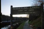
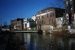
Manayunk
Site #8
Each presentation is in
three parts. The introduction, which explains the history of the
entire Pennsylvania Canal Network. Next is the individual site
presentation which is on this page. The final part is the ending
and credits which give due credit to those who created the texts
which we used in our research.
Manayunk Canal. 1.5 mile section of
Schuylkill Navigation Canal in vibrant canal-front community
of Manayunk in Philadelphia. Gravel towpath is now part of
Schuylkill River Trail. Canal completed in 1818. Good views
of Locks #68, #69 and #70 as well as of ruins of sluice
house, Locktender's house and Flat Rock Dam. The 108 mile
long Schuylkill Navigation, from Port Carbon to
Philadelphia, was completed in 1825, with 72 locks, 62 miles
of canals, and 46 miles of slack water. It operated until
1931. Maintained by Fairmount Park Commission in cooperation
with Manayunk Development Corporation. (215-482-9565, ext.
204).
In order to enjoy any of the multimedia presentations, you must
have Windows media player, a free download. In addition to being
free, the software has versions for all operating systems and
never asks you buy it. Download
it free here.